

Enjoy the sun while you can this week, because looks like rain and thunder are back in the forecast this weekend.
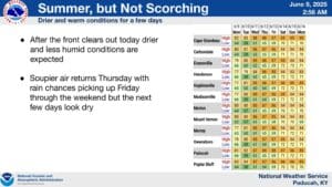
Once the rain moves out of the area on Monday, Tuesday is looking like the pick of the week—that’s according to Warning Coordination Meteorologist Christine Wielgos with the National Weather Service in Paducah, who says it should stay mostly dry all the way up until Friday.
Temperatures and dew points will start creeping up throughout the week, meaning it will feel a lot like summer, before thunderstorms bringing rain roll back in for the weekend. The good news, Wielgos says, is there looks to be no severe weather risk at this moment.
In the 8-to-14-day outlook, it’s looking like a familiar story, with above average chances for precipitation and about normal temperatures in store.
It’s a good thing that the weather looks to be calm the next couple of days, as the National Weather Service is doing required software upgrades to the NOAA Weather Radio Transmitters, which means your usual alerts for warnings won’t go off. This update should take about three days to complete.