

It’s looking like severe weather will be in store for the first half of the work week for western Kentucky and the surrounding region, with people encouraged to be prepared.
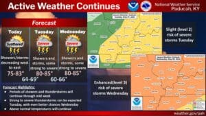
The first chance for severe weather moves in Tuesday afternoon—there will likely be some thunderstorms Tuesday morning, but the National Weather Service in Paducah isn’t expecting severe hazards with those storms. But if storms can fire up again Tuesday afternoon, then Meteorologist Justin Gibbs says they could become severe, with the threat conditional.
But if storms do ramp up, they would carry threats for damaging wind, hail and tornadoes.
But the most substantial risk for severe weather arrives Wednesday afternoon, with the bulk of the region—including all of western Kentucky—already highlighted under an Enhanced Risk for severe weather. Gibbs says the atmosphere will be primed for volatile weather, including destructive winds and possibly long-track, strong tornadoes.
Details, such as locations and timing, will be ironed out as the event gets closer, but right now Gibbs says it’s looking like the bulk of the severe threat will be in the afternoon and evening.
Gibbs says they are pretty concerned that things could become dangerous on Wednesday, so they’re urging people to have their safety plans in place and take the time now to prepare for severe weather. After the storms exit Wednesday, the rest of the week looks pleasant and cooler, temperature wise.
Stay tuned to the WHOP Family of Stations for more updates on this severe weather system.