

Our summer-like warm weather will be broken up by some stormy weather this week, bringing it back into more seasonal temperatures.
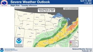
The week will start nice and warm, but Tuesday brings a storm-front through the area, though the worst of the severe risk looks to be to our north-east. Meteorologist Allan Diegan with the National Weather Service of Paducah says while a severe storm will be possible for the western Kentucky area, the main hazards will be gusty winds and hail, from Tuesday afternoon into the evening.
Rain chances will linger through Friday morning, which will moderate those warm temperatures back closer to normal.
Thursday will bring another risk for some severe weather, and although they’re not expecting much from it at this time, Diegan says it’s worth keeping an eye on.
With active weather in store for us this week, make sure you stay weather aware by staying tuned to both the National Weather Service in Paducah and the WHOP Family of Stations for any watches or warnings that may develop.