

It’s looking like rain will be the main story for the weather this week, after a sunny start with warm temperatures.
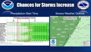
A weak cold front moves through the area Monday night into early Tuesday morning, bringing with it rain and a chance for some stormy weather—hail would be the main threat for any storms that do develop, according to National Weather Service in Paducah Forecaster Keith Cooley.
The chance for a severe storm or two lingers into the day Tuesday, but that Cooley says that threat is conditional, depending on if the sun can come out for some time before the secondary front moves through.
Then more rain is set move back in Thursday and into the weekend, bringing with it cooler temperatures.
In the 8-to-14-day outlook, Cooley says temperatures are trending warm with an above average chance for precipitation.
They’re not expecting severe weather with the Thursday front at this time for the area, with most of the severe threat looking like it will stay to our south. Stay tuned to the WHOP Family of Stations for any changes to the forecast that may occur.