

Some places to our north west could see some snow this weekend into the start of next week, but that’s not looking too likely for the western Kentucky area.
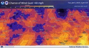
What is looking more likely for our area is going to be rain and a lot of wind—wind could get up to 40 miles per hour, maybe even higher, from about 3 a.m. until the evening on Tuesday, but the good news is that at this time, the National Weather Service in Paducah isn’t expecting any severe weather with this system. Justin Gibbs with the National Weather Service in Paducah says thanks to the leaves being off the trees, that will help cut down on any impacts in that area, though scattered power outages could certainly be possible if gusts get too high.
Some wind advisories could be in store of the area Tuesday.
Western Kentucky could also see some snow as the system moves out of our area, but they’re not expecting much in the way of accumulation. This weekend is looking gloomy and rainy for western Kentucky.
It is possible things could change as the system approaches, so stay weather aware as you head into the weekend—now would be a good time to prepare any winter weather emergency kits for your vehicle.