

Traveling will become very difficult by Wednesday night as an ice storm makes its way across western Kentucky and scattered power outages will also be likely.
An ice storm warning is in effect for western Kentucky until 6 p.m. Thursday. Christian and Trigg County Public Schools are closed Wednesday and will utilize non-traditional instruction. Heritage Christian Academy is also closed.
There were no travel issues reported in Christian or Todd County, but at least a few bridges and overpasses were slick in Trigg.
The Kentucky Transportation Cabinet is reporting numerous crashes to the north and west. Interstate 24 West is blocked by an overturned semi at the 46 mile-marker, and the eastbound lanes are blocked by a semi crash at the 35 mile-marker. Interstate 69 is blocked by a jackknifed tractor trailer at the 71 mile-marker.
The National Weather Service in Paducah was quick to point out in a conference call Tuesday afternoon that this event will not be as severe as the 1994 or 2009 ice storms, but Meteorologist Rick Shanklin says up to a half-inch of freezing rain accumulation on roads and sidewalks will make traveling hard.
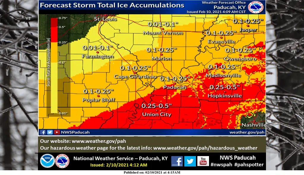
Power outages will be possible, especially in western Kentucky counties along the Tennessee border where the highest amounts of icing are expected.
Temperatures will likely hover at or just above freezing and allow some plain rain during the day, but the main event for freezing rain is projected for the Wednesday night and early Thursday morning timeframe, when it will be plenty cold to freeze.
The coldest air in over two years will move in late in the week, with Shanklin saying a wind chill advisory will likely be needed for at least part of the weekend, as wind chill values will go below zero.
Stay tuned to the WHOP Family of Stations and monitor our websites and social media outlets for the latest information.
From NWS in Paducah:
...ICE STORM WARNING REMAINS IN EFFECT UNTIL 6 PM CST THURSDAY...

* WHAT...Significant icing expected. Total ice accumulations of
  two tenths to almost a half inch is possible, with the highest
  amounts along the southern portions of the Western Kentucky
  Pennyrile and Jackson Purchase areas. Some sleet is possible as
  well.

* WHERE...Along and south of a line extending from Doniphan,
  Missouri, northeastward to Eddyville, Illinois, then eastward
  to Calhoun, Kentucky.

* WHEN...Ongoing until 6 PM CST Thursday with most of the
  precipitation occurring Wednesday night through Thursday.

* IMPACTS...Power outages and tree damage are possible due to the
  ice. Hazardous travel conditions are expected and could impact
  the morning and evening commutes.

PRECAUTIONARY/PREPAREDNESS ACTIONS...

Travel is strongly discouraged. If you must travel, keep an extra
flashlight, food and water in your vehicle in case of an
emergency. Prepare for possible power outages. Monitor the latest
forecasts for updates on this situation.