

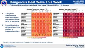
If you’re someone who loves summertime heat, then this week might be perfect for you, but you’ll still need to be careful as heat index values will top 105 degrees for the next few days.
In fact, there is now an Excessive Heat Warning in place for the entire region, including Christian, Todd and Trigg counties in western Kentucky, from now until Friday night. Meteorologist Sean Poulus with the National Weather Service in Paducah says temperatures in the 90’s paired with incredibly high humidity will make for downright miserable conditions, so they’re urging everyone to stay safe and cool.
The heatwave should break Friday night into Saturday, but it will still be a seasonal summer temperature for any Fourth of July celebrations. Poulus says there could be some storms that pop up in that time, but they’re not expecting much in the way of severe weather.
Then, in the 8-to-14-day outlook, it’s looking like fairly normal summer weather in store.
While our area of western Kentucky mostly dodged the torrential rainfall, areas to our north and east were hammered by catastrophic flooding, trigging a state of emergency declaration from the governor. That will certainly impact our drought conditions, but with high heat and no rain in this week’s forecast, we’ll see how that shakes out.