

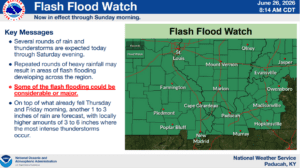
The weekend is looking rather stormy for western Kentucky, with a Flash Flood Watch in effect and chances for severe storms in place.
That’s according to the National Weather Service in Paducah, who issued a Flash Flood Watch following heavy downpours Friday morning. Several more rounds of rain and thunderstorms at expected into Sunday morning, with another one-to-three inches of rain likely to fall. Locally higher amounts between three-to-six inches of rain will be possible, where more intense thunderstorms develop.
That means flash flooding could develop across the region so remember, turn around, don’t drown.
Then, there’s a Slight Risk of severe weather in store Friday and a Marginal Risk forecasted for Saturday. Damaging winds are the main threat from any storms that crop up, but a tornado can’t be ruled out.
Once the rain moves out this weekend, temperatures are set to skyrocket next week, with highs in the upper 90’s. Those temperatures paired with high humidity will give us heat index values of up to 110 degrees possible, so make sure you’re drinking plenty of water and taking frequent breaks in air-conditioning if possible.
Stay tuned to the WHOP Family of Stations for any watches or warnings that may develop with our summer storm system.