

March has come in like a lion across the country this spring severe weather season, and it looks like western Kentucky will get a turn this week.
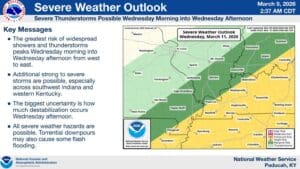
Things were start out warm on Tuesday, with Meteorologist Derrick Snyder with the National Weather Service in Paducah saying temperatures in the 80’s will set the stage for the possibility of severe weather. All hazards would be possible on Tuesday, but mostly to our north and west, though Snyder says a stray storm in our area can’t be ruled out.
The bulk of the severe risk will move into our area during the early morning hours, and Snyder says Wednesday’s risk is fairly conditional. A lot of it depends on what develops Tuesday night and in the morning hours Wednesday—if we’re able to destabilizes the atmosphere Wednesday, severe storms could be in our cards.
Along with the hazards for damaging winds, hail and tornadoes, torrential rain is also a possibility, with most areas on track to receive between an inch and a half to two inches of rain.
Once we get through our active weather Wednesday however, Snyder says things will mellow out, with a drier, cooler weather pattern settling in.
In the 8-to-14-day outlook, it’s looking like temperatures will stay near average, with below average chances of precipitation in store. Stay tuned to the WHOP Family of Stations for any watches or warnings that may develop this week.