

The National Weather Service in Paducah is advising folks to not unbatten those hatches just yet, as our Winter Storm Warning continues through Sunday afternoon, and an Extreme Cold Warning is in effect.
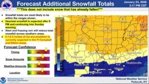
Meteorologists are calling for the possibility of another four to seven inches across western Kentucky, with higher amounts likely to our north, and then places in Christian, Todd, Trigg and surrounding counties could get around an inch of sleet and a quarter of an inch of ice, as the precipitation switches over to sleet and freezing rain. The more sleet and ice we get, the less snow, but it will make area roadways even more treacherous to traverse.
The Extreme Cold Warning is in effect now, and will last at least through Tuesday morning. Frigid temperatures and wind chills will combine to the feels like temperatures drop to 10 or 15 degrees below zero.
Those types of temperatures should be taken very seriously, as they can rapidly result in frostbite and hypothermia if the correct precautions are not taken.