

While we are in store for a blisteringly hot start to the work week, just hold on—because relief is on the way for the weekend.
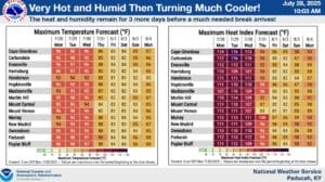
An Extreme Heat Warning is in effect for the entire area Monday and Tuesday, which means it will be somehow hotter than it was even during the past week, with heat index values of 110 to 118 degrees possible in some areas. That can quickly lead to a heat related illness, so make sure you’re staying inside in the air-conditioning as much as possible, and stay hydrated.
It’s also recommended to child on the elderly and bring those outside animals inside if possible—if not possible, make sure they have constant access to water and shade that isn’t a dog house.
Meteorologist Sean Poulos with the National Weather Service in Paducah says it’s been a summer of records so far, including extended heat, prolonged dew points and rainfall.
But there is relief in sight, says Poulos, as a cold front will bring the chance of storms Wednesday, ushering in cooler temperatures behind it. Any storms that develop will bring with them the hazards of gusty winds and hail.
Comparatively, the cool temperatures that will follow might even feel like fall-time, with temperatures dropping into the 50’s at night and just nudging into the 80’s during the weekend.
There’s still plenty of summer-time left though, as August will start warming up again immediately, with the 8-to-14 day-outlook showing above average temperatures in store and about normal chances of precipitation.