

And it’s second verse, same as the first when it comes to the weather in western Kentucky this week, which means hot temperatures and daily chances for pop-up storms and rain showers.
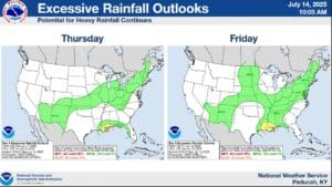
That’s according to Lead Forecaster Rachel Trevino with the National Weather Service in Paducah, who says that any storms that manage to develop could become severe at times, with damaging winds possible, and especially heavy rain. Trevino calls these storms efficient rain-makers, which means there will be the possibility of flooding conditions in the usual areas.
The best chances for storms will be during the hottest parts of the day—and it will certainly be hot, with high humidity helping to push those heat index values up into the low 100’s for the rest of the week.
Hopefully that forecast sounded good to you, because it will likely be more of the same heading into next week as well, with Trevino saying the 8-to-14 outlook shows above average temperatures and above average chances for precipitation.
With the ground saturated with consistent rain and the air heavy with moisture, flooding issues could certainly arise, so stay tuned to the WHOP Family of Stations for any watches or warnings that may be issued.