

Summer is coming in hot this week—and we mean that literally, because we’ll likely see some of the hottest temperatures so far this year, along with chances for storms and rain through the week.
In fact, there is a Flash Flood Watch in effect for all of western Kentucky and surrounding areas until early Tuesday morning, with Meteorologist David Witten saying any storms that manage to spring up Monday or Tuesday could drop an inch or more of rain pretty quickly.
He says the risk of severe weather on Wednesday as increased some, particularly in southern Missouri and Illinois areas, but there could be strong to severe storms in our area as well, with the main risks being damaging wind and large hail, though a tornado can’t be ruled out.
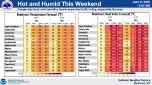
On top of a good bit of rain being possible, the region will also experience its hottest temperatures of the year so far, with Witten saying the heat index could reach between 100 and 105 degrees heading into the weekend.
The good news is, the weekend looks to dry out completely, with only minor chances of rain on Saturday and Sunday. Stay tuned to the WHOP Family of Stations for any watches or warnings that may develop.