

Friday morning’s storms have done little to bring down our risk for severe weather in western Kentucky, with the entire region remaining under a Moderate Risk for severe weather.
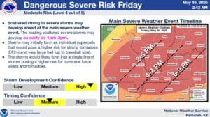
That Moderate Risk comes with all hazards possible—hurricane-force winds, very large hail and tornadoes. Meteorologist Kate Shawkey with the National Weather Service in Paducah says if supercells can develop, then some of those tornadoes could be strong, and even when the storms form into a line, the tornado risk won’t go away.
Usually, storms in the morning could result in less severe threat later in the day. Shawkey says that’s not the case for this event, as the clouds are already clearing out, leaving the atmosphere to once again become unstable enough for severe storms.
Damaging winds will likely be prevalent in any storms that develop, especially if they congeal into a line, with significant hail and tornadoes still possible.
Right now, the National Weather Service believes the storm activity will take place mostly in the afternoon and evening hours, but if supercells starting popping up, then the risk could begin as soon as 3 p.m. in the western Kentucky area.
It’s looking like it will be a volatile day for weather, so make sure to stay tuned to the WHOP Family of Stations for any watches or warnings that may develop.