

Folks across the region battened down the hatches over the weekend for severe weather—and you might as well go ahead and leave them battened, because a slew of severe weather is in store for this week.
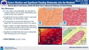
Monday and Tuesday will be calm, but then Wednesday brings our next significant chance for severe weather, and it could be a doozy. At least that’s according to Meteorologist Justin Gibbs with the National Weather Service in Paducah, who says all hazards will be on the table for Wednesday’s storms, including widespread damaging winds, large hail and maybe even strong tornadoes. While Wednesday carries our highest chance for severe, the possibility will linger through the rest of the work week.
Right now, the timing for Wednesday looks to be in the afternoon and into the evening hours, but that could still change. The whole area is already under an Enhanced Risk for severe weather that day, and Gibbs says storms will just linger over us for a few days.
Those storms training in the same areas is what is resulting in a startling projection for rainfall amounts—right now, the National Weather Service says some places in western Kentucky could see between 10 to 15 inches of rainfall between Wednesday and Saturday.
Gibbs says that’s not a projection you really ever see, so people need to take this flooding risk seriously, as flooding will quickly become very dangerous and life-threatening, if those projections come true.
Gibbs says this spring severe weather season has already been a long one, and its just now the first week of April, so he knows people are getting tired. Don’t let your guard down, and take the time to prepare now for any potential severe weather and flash flooding that may develop.
Stay tuned to the WHOP Family of Stations are more information comes out about this week of active severe weather.