

This spring severe weather season has already been an active one, and that only continues for Sunday and then again starting on Wednesday.
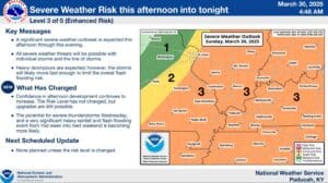
First, let’s worry about one thing at a time—starting in the afternoon Sunday locally, the National Weather Service has all of western Kentucky under an Enhanced Risk of severe weather, with all hazards possible, including damaging winds, very large hail and some tornadoes.
Senior Forecaster Allan Diegan with the National Weather Service in Paducah says there are still some questions about if supercell development will occur in the afternoon, but ultimately, a line of severe thunderstorms will likely race through western Kentucky in the evening.
Once we get through these storms, attention turns to Wednesday, where the region—including the Pennyrile—is already under the gun for severe weather, including strong tornadoes. When those storms move through, a heavy rain event is expected to linger through Saturday, with some places in western Kentucky possibly receiving up to ten inches of rain in that time.
That means flash flooding is likely, even outside of the usual low-lying and poor drainage areas. There are still more details to determine for both of those weather events, so stay tuned to the WHOP Family of Stations as more information becomes available.