

Spring is in the air—and we mean that literally, as the weather is looking like a classic spring set up this week, split between sunny and stormy skies.
The region certainly had its fair share of stormy weather over the weekend, though western Kentucky managed to escape with no severe weather. That did not hold true for other areas covered by the National Weather Service in Paducah, with at least six reported deaths caused by severe weather in Missouri as numerous tornadoes, many of them strong, touched down Friday night into Saturday morning.
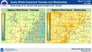
Meteorologist Justin Gibbs says it was a long night, but with the spring severe weather season just beginning, there will likely be more. After a sunny, mild start to the work week, Wednesday looks to bring another marginal risk of severe weather to the region, and it’s going to be downright blustery.
A Wind Advisory is certainly possible in the mid-week, and after stormy weather moves through Wednesday, we’ll get a brief break before another chance for severe storms arrives on Sunday. That event is too far out to have much in the way of details, but Gibbs says they’re keeping an eye on it.
In the 8-to-14-day outlook, the data is showing above average temperatures in store, along with above average chances of precipitation—a good indicator that while we may have a few cold nights still to go, spring is here to stay.