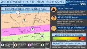
Our first risk for wintry weather of 2025 is bearing down on the region this weekend, and the National Weather Service in Paducah is keeping a close eye on it.
Lead Forecaster Keith Cooley says northern counties remain the most likely to see serious impacts from winter weather, but counties along the Kentucky-Tennessee line could still see some frozen stuff mixed with rain—and that’s all subject to change before the system arrives Saturday night.
One thing that is certain is that temperatures will become downright icy, with highs being in the teens, and then the overnight hours could become dangerously cold with temperatures near zero.
Cooley says it would be wise to prepare now, whether that be by winterize your home by protecting vulnerable pipes or putting together an emergency kit for your vehicle.
There are plenty of details to be ironed out about this weather system between now and when it’s expected to enter the area Saturday night into Sunday morning—so make sure you stay weather aware and stay tuned to the WHOP Family of Stations for more updates as they come out.


