

Hopefully you enjoyed the cooler start to the week, because it’s not sticking around—temperatures and humidity are set to ramp back up, bringing daily chances of rain and storms with them.
Meteorologist Derrick Snyder with the National Weather Service in Paducah says Monday was the best day of the week temperature wise, but then we’ll be back until the realm of heat advisories starting mid-week.
Rain will linger through the week, with the best chances on Wednesday and again on the Fourth of July—so firework shows could be jeopardy.
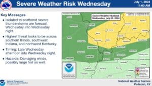
There is a marginal risk of severe weather in the western Kentucky region for Wednesday night into Thursday morning at this time, with damaging winds and hail the primary threats.
Then in the 8-to-14 day outlook, those above average temperatures look to hang around, with an above average for precipitation in the trends.