Rain will be the name of the game weather wise this week, along with above average temperatures—getting summer off to a muggy start.
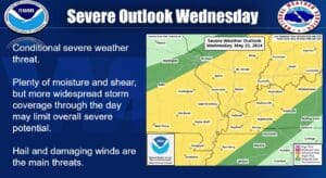
Lead Forecaster Keith Cooley with the National Weather Service in Paducah says the week starts out hot, with temperatures touching near 90 on Tuesday, before a new round of active weather moves in heading into Wednesday—which could bring with a good chance for heavy rain and maybe some severe weather.
The severe weather threat at this time is conditional, which means depending on much rain and storms develop in the morning will determine what severe storms form in the afternoon Wednesday. Cooley says most of the area is highlighted under a Slight Risk for severe weather.
Heavy rain will be a risk, especially where any thunderstorms form and hang out, so there does exist the potential for some flooding in the mid-week. The main severe risks—if any develop—would be hail and damaging winds.
Stay tuned to the WHOP Family of Stations for any watches or warnings that may come out of this developing weather system.


