

the National Weather Service in Paducah is keeping an eye on severe weather that may move through the region during the beginning of the week along with a cold front set to result in lower temperatures.
On Monday through Wednesday, Meteorologist Derrick Snyder with the weather service shared that Western Kentucky could be impacted by some inclement weather. Monday evening, Snyder says there is only a marginal risk for storms, scattered showers, large hail and damaging winds, but believes the threat will mostly be to our east.
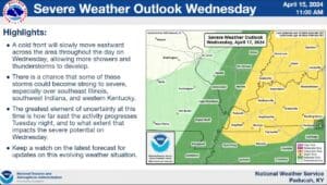
Tuesday’s storm risk is mainly to the west in Missouri and Illinois with Western Kentucky being at a marginal storm risk again. However, Snyder says Tuesday’s storms could redevelop as a cold front moved through the region from the west on Wednesday.
Western Kentucky is in a slight risk zone for storm formation, but Snyder says the strength of Wednesday’s storm depends on how far east Tuesday’s storms reach which could result in stronger storms.
Snyder says confidence is low on Tuesday’s storm activity greatly impacting Wednesday’s forecast, but they will keep a close eye on it.
As a result of Wednesday’s cold front, Snyder says toward the weekend temperatures will take a slight dip.
Snyder says the temperature drop could stick around through early next week.