

A cold front approaching from the west is bringing possible thunderstorms, hail and tornados to western Kentucky Tuesday evening into early Wednesday morning, but areas closer to the Tennessee border are at lower risks of experiencing severe weather.
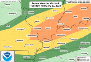
National Weather Service in Paducah meteorologist, Chris Noles hosted a severe weather conference call to talk about the incoming inclement weather on Tuesday. Noles says areas in northwest Kentucky, southern Indiana and southern Illinois are under an enhanced severe thunderstorm risk while the majority of the Pennyrile region and areas closer to the Tennessee border are under a slight to marginal risk.
The orange section on the map notes the enhanced risk area, yellow notes the slight risk area and green notes the marginal risk area. Noles advises for residences that may not be in higher risk areas to still remain alert.
The chances for tornados in the region also remain north of the Pennyrile region where there is only around a 9% to 2% chance a tornado forms.
Noles says the storm front is set to move into the region at around 7 p.m. to 8 p.m. and the front will make its way through the Pennyrile Region by early Wednesday morning and the storm should not be as severe.
After the storm passes through the region, Noles says temperatures will have a slight drop before temperatures increase by the weekend.
