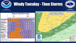
It is unusually warm for February this week, before a cold front moves through to cool things down and bring with it a chance for storms.
Forecaster Sean Poulos with the National Weather Service in Paducah says the unseasonably warm temperatures we’ve been experiencing continue this week, with some places possible reaching 80 degrees on Tuesday, which would be a record.
He says a cold front moves through the region Tuesday evening, and that will bring with it a chance for storms, some of which could be strong or severe, especially in northern areas.
Storms could form a line as they move through, with the main hazard being damaging winds, but a tornado could not be ruled out if the severe potential over performs and super cells develop.
Poulos says they’re not expecting a widespread outbreak of severe weather—most of a western Kentucky is a marginal risk for severe weather, In the 8-to-14-day outlook, warm temperatures look set to continue and there’s an above average chance for precipitation.
They are keeping an eye on a weather system set to enter this part of the country early next week that could bring a risk for severe weather, but Poulos says its still too far out to iron out any details. Stay tuned to the WHOP Family of Stations for updates to this developing weather system.


