

With more inclement weather on the horizon, the National Weather Service in Paducah hosted a weather conference call on Wednesday where they shared a forecast for freezing rain and the continuation of frigid temperatures.
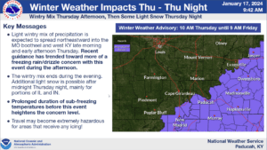
Sean Poulos with the National Weather Service shared that portions of west Kentucky reaching Christian, Trigg and Todd Counties will receive precipitation on Thursday. However instead of more snow, Poulos says the forecast is pointing more toward a freezing rain or drizzle.
According to Poulos the chances for freezing rain are higher for areas located closer to the Tennessee border.
Poulos says the freezing rain is traveling northeast from the Missouri Bootheel and will strike at around 11 a.m. on Thursday and travel across western Kentucky throughout the afternoon. Poulos says they are expecting a tenth of an inch of ice accumulation at most and the possibility of a light snow dusting in the region.
With roads possibly being icy, Poulos says traveling conditions may be hazardous which has led to a winter weather advisory being declared for Thursday and Friday. Poulos says they are not expecting more freezing rain on Friday but extended the advisory because the roads may still have ice from Thursday.
Following Thursday, Poulos says their will be another blast of arctic air resulting in below freezing temperatures and breezy conditions.