

Cold temperatures stay firmly in place this week, before a warm up in the weekend—but before that, another chance of winter weather arrives Thursday.
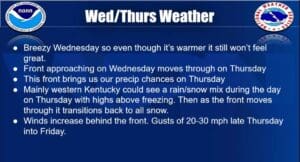
Forecaster Kate Shawkey with the National Weather Service in Paducah say it will remain bitterly cold the first half of the week before a very slight warm-up on Wednesday. But then a cold front moves back into the area, bringing with it renewed snows chances, especially in western Kentucky.
Some places could see around an inch of accumulation, with Shawkey saying it this point, the event looks light, though that could change as we get closer. Then temperatures will dip near zero again, especially with the wind chill, which could put us into the negatives.
If you’re sick of those temperatures, just hold on, because on Sunday it looks like the cold snap will finally break, with Shawkey saying temperatures will steadily rise, up into the 40’s and maybe even 50 to start the work week.
In the 8-to-14 day outlook, things continue to trend warmer than average, and with above average precipitation, with Shawkey saying our weather pattern is looking rainy.