

The region could see its first chance of snow in the air for the winter this week, but western Kentucky shouldn’t expect much in the way of accumulation.
Meteorologist Sean Polous with the National Weather Service in Paducah says the coming days should be much cooler—especially compared to the very warm Christmas we had—with temperatures settling into a more average 40’s.
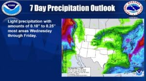
The cooling temperatures will bring with them a chance for rain and maybe even some flurries, as a tricky cold front moves through the area.
The best chance for snow will be to our north—but Polous says they’re expecting very little impacts from anything that does stick.
After that, things are looking fairly average both for temperatures and rain in the 8-to-14-day outlook, with conditions set to be fairly dry heading into the new year. This Christmas was one of warmest on record, and was the wettest Christmas since 2006 locally.