With a Winter Storm Watch in effect from 9 p.m. Thursday until 9 p.m. Friday, the Kentucky Transportation Cabinet says it plans to have pre-treated portions of I-24, I-69 and the Purchase Parkway before the ice, sleet and snow arrive.
Transportation Cabinet Spokesman Keith Todd says in a news release that their SuperTanker will initially be running along I-24 between the Ohio River Bridge at the Kentucky-Illinois state line to about the 74 mile marker near the Trigg-Christian County line. Todd says I-24 won’t be treated in Christian County as more regular rain is expected to fall the farther east you go before the temperature drops and it would wash the brine solution away.
Once I-24 is pre-treated the SuperTanker will move on to I-69 in Lyon County and then the Purchase Parkway.
When a brine solution is sprayed on pavement surfaces it dries to leave a fine powder that is available to be activated in the early hours of a snow and ice event. It initially helps to improve driving conditions, but also keeps snow and ice from bonding to the paving making it easier to plow off as the winter event continues.
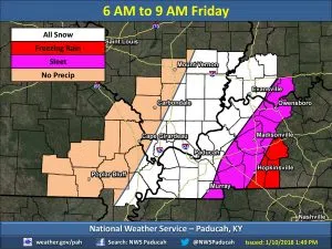
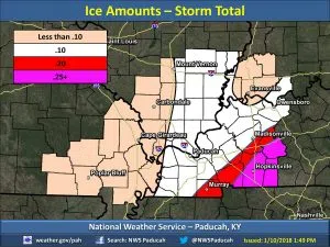
The National Weather Service in Paducah hosted a conference call Wednesday afternoon, when lead forecaster David Humphrey said Christian, Todd and Trigg counties can expect about a quarter-inch of ice accumulation.
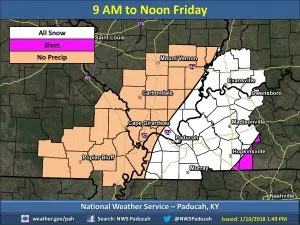
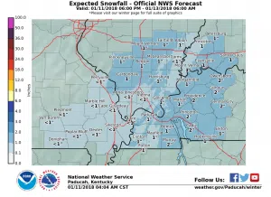
Freezing rain will eventually transition to sleet and then snow and the southern Pennyrile will likely see up to two inches.
Warning Coordination Meteorologist Rick Shanklin says a quarter inch of ice combined with gusty winds could mean some power outages in the area.
The transition from plain rain to freezing rain is expected to begin between 3 and 6 a.m., meaning the Friday morning commute is likely to be treacherous.
Stay tuned to the WHOP Family of Stations and monitor our websites and social media outlets for the latest on this developing winter storm.